Flavio Dobran
Abstract
Mitigation of volcanic disasters in densely populated areas can be based on emergency plans or interdisciplinary systems integration guidelines. An emergency plan is designed to wait for an eruption and manage evacuation, whereas an interdisciplinary approach aims at reorganizing the territory to minimize the impact of future eruptions and evacuation. The latter approach is advantageous for a densely populated area because of our inability to forecast future eruptions more than several days or weeks in advance and evacuate large number of people who may be ignorant about the risk or do not wish to evacuate, because of the difficulty in confronting the socio-economic and political consequences caused by a massive or false evacuation, due to the unpracticality of protecting a rich territory from speculators after the eruption for a long time; or due to the unwillingness of the population or the nation to accept the destruction of its culture by a failure to evacuate or evacuate to faraway places.
1. Introduction
There are many places around the world where people live and work in the proximity of dangerous volcanoes, and where the problems of decreasing the volcanic risk caused by future eruptions are becoming more and more difficult to solve as the population density increases with time. A volcanic risk is defined in terms of the potential hazard produced by an eruption, degree of vulnerability of people and infrastructures and value of the territory exposed by future eruptions. A volcanic hazard is measured in terms of the probability of an eruption event occurring at a given place and time which in the extreme situations can be effusive, when a volcano produces slow moving lava flows, and explosive, when it produces high rising volcanic clouds of gas and ash and ground-hugging pyroclastic flows which move at very high speeds along the slopes of the volcano. People, houses, transportation, and communication routes and systems, such as the layout of roads, bus and train routes, sewers, water supply lines, electrical power and telephone lines, and cultural and archaeological sites are all vulnerable in different degrees to different eruptions and can only be defined in terms of probability of the vulnerability. In turn, each of these infrastructures has a different value which may be very difficult or impossible to estimate for the proper calculation of the risk. A volcanic risk thus constantly changes not only because of the hazard but also because of the changing socio-economic conditions of people exposed to the hazard. Moreover, a population surrounding a volcano may consider the preservation of its culture essential, which further complicates the risk balance equation.
It is, therefore, necessary to possess reliable data which define the risk before concluding that a population around a dangerous volcano needs to be resettled or the area isolated from future developments. More confusion and fear about a problem are often created from the ignorance of the problem or by ignoring it instead of confronting it and actively participating in its solution. Ordinary people living in high risk areas and equipped with the necessary educational background about the risk are often better judges of reality of this risk than its managers who tend to be biased by their own interests, and by those who want to exploit the territory for their own gains. An ordinary person living in a volcanic risk area is not very much concerned with the future eruptions and their effects on the area, for from his or her often limited experiences he or she learned that the potentially dangerous volcanic eruptions in the area are rare and that the burden of the problem of risk mitigation should be delegated to the future generations who want to live on the territory. As a consequence, the majority of people tend to adopt or live in harmony with volcanoes and only become moved when volcanoes begin showing signs of unrest or when they begin to change their lives in some concrete manner. The basis for volcanic risk reduction in densely populated areas should, therefore, involve an interdisciplinary scientific approach where science and social, political, and economic factors of the territory play important roles in risk mitigation.
Waiting for an unrest of a hazardous volcano and then trying to manage the hazard may only prove effective in non-densely populated areas where the social, political, and economic factors are easily manageable. Such an approach of risk mitigation, which is currently being practiced by volcanologists, has severe limitations and cannot be considered as a valid approach when trying to reduce the volcanic risk in densely populated areas. Vesuvius is an excellent example of a runaway problem where the international volcanological community and volcanic risk managers of the area have been unable to produce the necessary scientific data for developing a reliable volcanic risk mitigation plan for the territory and are keeping three million people hostages of their own destinies. If we fail to provide concrete solutions for the Vesuvius area, we will be confronted tomorrow with similar problems in other parts of the world with increasing chances of having to deal with an unprecedented human and environmental catastrophe.
The purpose of this paper is to discuss two different approaches of volcanic risk mitigation in densely populated areas. The first approach, currently practiced by volcanologists, does not represent a viable strategy when dealing with densely populated areas, because of the unavailability of necessary data to produce reliable eruption forecasts and evacuate on time hundreds of thousands of people who may be largely ignorant of the risk and consequences of evacuation. The proposed alternative is based on interdisciplinary systems integration that aims at creating a multitude of different options for the territory which are necessary for taking decisions by the population whether to live and work on the territory or how to behave during future eruptions.
2. Lessons From History
The historical record indicates that about 1 million people have been killed by volcanic eruptions in the past 2,000 years where most of the deaths occurred in few eruptions. In the twentieth century the 1902 eruption of Mont Pele'e on the island of Martinique in Central America killed about 25,000 people, whereas Nevado del Ruiz Volcano in Colombia killed in 1985 another 25,000. In the nineteenth century the two eruptions in Indonesia, Tambora in 1815 and Krakatau in 1883, killed about 120,000 people. In 1792 the eruption of Unzen Volcano on Kyushu, Japan killed about 15,000. The eruption of Vesuvius in 1631 near Naples in Italy killed about 10,000 people, whereas the 79 eruption that destroyed Herculaneum and Pompei produced about 2,000 deaths. The city of San Salvador in San Salvador in Central America lies close to a lake which was produced from a massive eruption around 300 which according to estimates displaced or killed thousands to hundreds of thousands of people and changed the course of local civilizations by benefiting the Mayans living in the Pete'n and Yucata'n areas. Another massive eruption on the island of Thera or Santorini in the Aegean Sea in the Mediteranean witnessed around 1600 B.C. an eruption that devastated an entire region and shipping trade. This eruption apparently changed the course of the Western Civilization by diminishing the influence of the Minoan culture in the region and benefiting the development of the Mycenean culture of mainland Greece [1-6].
The countries with the highest volcanic risk are those which contain explosive volcanoes, such as Italy, Indonesia, New Zealand, Papua New Guinea, the Philippines, Japan, Russia, the United States, Mexico, Central America, Colombia, Equador, Peru and Chile. Some of these countries cannot afford to develop effective risk mitigation programs and must look upon the industrialized nations for concrete examples of effective risk reduction. The 1902 eruption of Mont Pele'e which destroyed the town of Saint Pierre occurred because its governor, fearing the loss of the election, did not issue an evacuation order on time in spite of the premonitory earthquake signs which shook the region for several weeks. The town of Armero situated in a valley of Nevado Del Ruiz Volcano was built on a mudflow but the town officials did not take any coordinated effort to evacuate the population from the valleys below the mountain in spite of the premonitory signs that the volcano become active again. The melted snow produced from this activity, in 1985, buried again the town of Armero in mudflow where about 25,000 lives were lost [1,2]. In 1986 the volcanic activity at Lake Nyos, Cameroon, produced a poisonous carbon dioxide cloud which moved down the valleys of the lake during the night and killed several thousand people and displaced thousands [2], while about 60,000 people were evacuated from the valleys of Mount Pinatubo, Philippines, in 1991 only moments before a large explosive eruption [7]. On the other hand, a false evacuation of about 70,000 people on Guadaloupe Island in the Caribbean in 1975 from the rumblings of La Soufrie're Volcano proved to be very costly and debatable for a long time [2]. The eruption of Mt. Helens in the United States in 1980 saved, however, many lives by closing the approach roads to the Mt. St. Helens' national park which contains the volcano [8].
Catastrophic eruptions of volcanoes not only killed thousands of people in the past but also produced worldwide atmospheric effects which are dangerous for human survival. The eruption of El Chicho'n in Mexico in 1982 produced a worldwide atmospheric disturbance by dumping high into the atmosphere millions of tons of gas and ash which spread westward and affected the climate because of the high quantity of sulfur in the erupting cloud. The eruptions of Laki Volcano in Iceland and Asama Volcano in Japan in 1783 may also had caused a worldwide effect on the climate, for an explosive eruption produces a rapid ascent of the cloud, erratic winds and condensation of erupting gas and moisture in the air that produces rainfall. In very large eruptions, dark ash clouds can spread downwind for hundreds of thousands of kilometers and produce global weather disturbances, such as after the 1883 eruption of Krakatau where it is estimated that the erupting cloud reached a height of 50 km. The eruption of Tambora in 1815 produced a cooling of the Earth in 1816 because the erupted ash particles in the atmosphere absorbed some of the sun's energy normally used to heat the surface of the Earth. Volcanic gas also contains chlorine which may affect the distribution of ozone in the atmosphere that shields the Earth's population from deadly ultraviolet rays [2,6].
3. Candidates for Future Catastrophes
By a volcanic catastrophe we mean an eruption which is devastating enough to change the social order of an entire region. According to this definition, it is thus impossible today to forecast such a catastrophe for it may occur from a volcano which has been dormant for hundreds or thousands of years. We can, however, classify several of the well- known volcanoes as being excellent candidates for future catastrophes, for each of these can produce a significant change of social order and economic well- being of a nation.
Vesuvius in Italy has been erupting for the last 17,000 years by producing large (plinian) explosive eruptions every few thousand years and medium (subplinian) explosive eruptions every few hundred years. The 79 plinian eruption buried the Greco-Roman cities of Pompei and Herculaneum, devastated the surrounding territory, and made the area unproductive for several centuries. About six hundred years later, in 1631, the subplinian eruption produced an even greater damage on the territory because of much greater population density and killed about 10,000 people. After this eruption, Vesuvius entered a phase of strombolian and effusive eruptions where some of them also produced a great deal of damage, such as the eruption of 1794 that destroyed Torre del Greco, and the eruption of 1944 which destroyed San Sebastiano al Vesuvio [9-11]. Vesuvius is now preparing for its next reawakening which may be large or medium in intensity, and can cause an unprecedented human and environmental catastrophe due to the high population density very close to the crater of the volcano. Even a small eruption could produce tens or hundreds of thousands dead and affect at least 3,000,000 people who live in the 30 km radius of the volcano where the infrastructures are totally inadequate for the territory of such a high risk. There are about 1,000,000 people in the 7 km radius of the volcano with population density as high as 15,000 people per square kilometer (Portici, San Giorgio) [12,13]. To make things worse, the Italian volcanologists (mainly from Pisa) convinced the government to propose an unreliable Emergency Plan for the Vesuvius area that gives a false sense of security [14].
Popocatepetl in Central Mexico separates Mexico City and Puebla valleys with more than 20 million inhabitants and during the last 5,000 years it exhibited several cycles of activity, with the most recent from 675 to 1095. In the course of this activity, the volcano devastated local settlements and apparently caused the decline of the great ceremonial center of Cholula. In 1994, Popocatepetl or the smoking mountain resumed its activity and even caused the evacuation of about 75,000 people from its eastern flank [15,16]. Today, El Popo, like Vesuvius, is being closely monitored for the changes of its activity which is of little comfort to several hundred thousand people who live in the 15 km radius that could easily be affected by a moderate eruption [17]. The Emergency Plan for this volcano is of better quality than that of Vesuvius because it is simpler and much less pretentious, but still based on the volcanological or emergency management approach and open to severe criticisms because of the subjective nature of decisions leading to crisis management and evacuation [15,18,19].
The snow-covered Mount Rainier, rising majestically behind Tacoma and Seattle, Washington, in the United States, has a history of producing massive avalanches and mudflows from its slopes which in the past reached the areas occupied today by these cities. Its last activity in 1882 has apparently being forgotten by the local administrators who are doing nothing to prevent a future catastrophe in this region. Taal is a volcano within a huge caldera lake only 50 km from Manila, Philippines. This killer volcano has erupted more than 30 times since 1572 and is also an excellent candidate for producing a human and environmental catastrophe, both locally and globally due to the very high population density in this part of the world [2,4].
The above volcanoes are only several examples that can produce human and environmental catastrophes, because of the subjective nature of the word catastrophe and the number of fatalities that can be associated with such a word. For a family, a catastrophe can signify the loss of most of its members, for a town the loss of several hundred or thousand people, for a region the loss or displacement of hundreds of thousands, and for a country the collapse of the government or political upheaval. The word catastrophe also imprints upon our mind our inability of confronting the problem. Is this because we are powerless to define the dimension of such a problem, or are our tools used to cope with this problem insufficient?
4. Eruption Forecasting
Volcanic eruption forecasting is a very subjective human endeavor where the best forecasts range from hours to few days as in the cases of the Mt. St. Helens eruption in 1980 and Mt. Pinatubo eruption in 1991. The eruption of Mount Ruapehu in New Zealand in 1996 set plumes of ash and steam 16 km high into the atmosphere only six days after the scientists declared that its volcanic activity has subsided [20]. In 1993 six volcanologists studying the Galeras Volcano in Colombia lost their lives when the volcano exploded with lava, ash, and incandescent boulders.
Volcanologists base their eruption forecasts on the data obtained from monitoring of seismicity, deformation of the volcanic cone, gas emissions, hydrological regimes, and magnetic, electric and gravity fields. A change of the seismicity of a volcano may be associated with the rearrangement or rise of the molten rock material within the volcano, since this causes rock fracturing and energy dissipation to the environment that can be detected by instruments on the surface of the Earth. Seismicity does not, of course, always lead to the conclusion that a volcano has become restless, because a seismic signal can also be produced by the tectonic motions in the region which may have nothing to do with the volcano. Nevertheless, a volcano in the process of eruption can produce seismic signals of "sufficient intensity" that may be representative of the event and can serve as precursory signals for an eruption. Similarly, the ground movements may provide good indications that the volcano is preparing for an eruption, especially when these movements become "large enough" in comparison with the background noise or instrument errors. Changes in the electrical conductivity, magnetic and gravity fields can trace molten rock movements inside a volcano and may be detected even when a volcano is not preparing for an eruption. Changes of the composition of the emitted gas from a volcano may be related to the rearrangement of the molten rock within the volcano or gas escape routes through its fractured medium. Moreover, the changes in ground water temperature or level, lake levels, snow and ice accumulation, and the transport of sediments in the stream can also be considered useful signals for the issuance of eruption forecasts [4]. In the case of the May 18, 1980 Mt. St. Helens eruption, the abrupt onset of deep earthquakes and ground deformation on May 17 caused the scientists to issue the eruption forecast [8], whereas the eruption of Pinatubo in 1991 was forecasted two days before based on "intense unrest, including harmonic tremor and/or many low frequency earthquakes" [7].
It is very important to realize that today's eruption forecasts are based on very narrow windows of hours or several days, and that this can produce a catastrophic consequence in a densely populated area, since it is unpractical to evacuate hundreds of thousands of people on a very short notice and possibly in a state of panic. To accomplish such an evacuation successfully may require the issuance of an evacuation order weeks or months in advance, which scientifically cannot be reliably forecasted at the present time. As a consequence, the politicians who must issue such orders are given no alternative but to wait until the last minute in order to avoid a false evacuation and be held responsible for the unnecessary expenditure of very large local or national resources. The end result of this conflict between the uncertainty of eruption forecasting and interest of avoiding a false forecast, as well as the interest of local politicians to keep the population ignorant about the risk in order to govern them more easily, can only produce a tragedy for those who have left their destiny in the hands of those who are no better equipped with facts than they are. We should, therefore, not forget the tragedies which occurred because of the eruptions of Mont Pele'e in 1902 and Nevado del Ruiz Volcano in 1985.
Basing a volcanic risk mitigation strategy in a densely populated area only on an emergency plan fails to address the problem properly and invites tragic consequences. Such an approach cannot only lead to a human tragedy, but also destroy culture, produce a speculation on the territory after the eruption, produce a political upheaval because of the tragedy or unnecessary expenditures of large national resources, slow down volcanological progress because it does not provide room for developing alternative volcanic disaster mitigation strategies, as well as lead to an increasing awareness among the public that the volcanic risk managers cannot even properly address the problem, let alone manage it. Current Emergency Plan for the Vesuvius area [14] is an example of such an approach which should not only shame its proponents from Pisa, national Civil Protection, and the Observatory in Naples, but also many prestigious national institutions of high learning, because they are failing to question the scientific, engineering, socio-political, and economic validity of such a plan [12,13].
5. Volcanic Risk Mitigation Based on Emergency Plans
Volcanic risk mitigation based on emergency plans assumes that the population can be evacuated safely before eruptions, or that the volcanologists are able to forecast the eruptions and that the politicians will act effectively on these forecasts. I already argued above on the flaws of this assumption, and to elaborate further it is instructive to take as an example the current Emergency Plan for the Vesuvius area [14].
Intense urbanization and inadequate planning of the Vesuvius area have contributed towards an increasing risk of living and working in the area where today live about 1,000,000 people. The elements which determine this risk are: the population density which is one of the highest in the world, important highway and railway connections between the North and South running along the coast, the communication lines and local transportation systems which are inadequate for the mobility of the population and largely insufficient for an area at risk, the local population which is unprepared for any volcanic event and which demonstrates a progressive loss of memory of past eruptions, the concentration of unestimated archaeological and architectural resources in the area, the local administrators who have been delegating and continue to delegate to the central government the problem of governing the territory when only the local communities can give adequate answers, and there is an absence of plans for the reduction of damages which could be produced by future eruptions [12,13,21,22]. A recent population survey of 3,000 people conducted in the area shows that 80 percent of the people are ignorant of the risk, or that the majority of the people are unable to judge for themselves the necessary issues which confront them [21].
The Emergency Plan for the Vesuvius area [14] assumes that an eruption of Vesuvius will be predicted at least two weeks before and that in one week before the eruption about 700,000 people can be evacuated from the area to different places all over Italy. As such, the plan fails on scientific, engineering, socio-politic, and economic grounds. The Plan is scientifically unfeasible because the most probable and maximum future volcanic events in the Vesuvius area are not justified; the unprocessed data from volcano monitoring are not being made available to the scientists and, therefore, precludes a proper scientific evaluation of threshold limits to be used for issuing different alarm and evacuation orders; and the Plan does not indicate who will be able to forecast the eruption at least two weeks before. The lack of forecasting an eruption is based on our ignorance of the substructural characteristics of the volcano, such as the composition of magma, location and size of magma reservoir, magma supply rate to the volcanic system, and mechanical, structural, and thermophysical characteristics of the volcanic edifice [23-25]. Current estimates of water contents in magmas vary from 1 to 3 wt% [26,27]. Basing a forecast on 3 wt% may require no evacuation at all, since an eruption will tend to produce a high rising volcanic cloud from which people can escape relatively easily. On the other hand, basing a forecast on 1 wt% has the tendency to produce a collapsing volcanic column that generates pyroclastic flows which can reach the Tyrrhenian Sea in less than 5 minutes [27,28], and will thus require the evacuation of many people. The engineering reliability of the Plan is not justified because it does not account for the functioning of communication and transportation systems preceding and during a volcanic crisis, such as traffic flow, electrical power, telephones, fuel distributors, transport vehicles along escape routs, railway tracks and signals, etc.; exit modalities from towns (who leaves first); and for the effects of earthquakes which could produce collapses blocking the evacuation routes. The socio-political reliability is not justified in the Plan because the local and national political effects, "destruction" of the Vesuvius culture, consultation and decision by the population to remain or leave the area, and the speculation caused by the evacuation to faraway places have not even been discussed. As further discussed below, given the cultural and political divisions of the country, such an evacuation is socio- politically unacceptable. The economic reliability of the Plan has not been calculated, such as the cost of a false alarm, cost of evacuation and re- entry, cost to avoid speculation and protect the area during and after an evacuation, cost to maintain the command and control centers in the area, cost associated with host regions which would have to house the evacuees for an undetermined time, and the cost of making the Plan reliable when its proponents refuse to discuss it at scientific meetings (IAVCEI's meetings in Rome, September, 1995; Naples, September, 1996; Puerto Vallarta, January, 1997) and in public in the Vesuvius area.
Current Evacuation Plan for the Vesuvius area does not only represent a failure of volcanologists who proposed it but also of politicians who approved it, for they should know better than trying to deceive the progressive scientific establishment and population of the Vesuvius area with a plan that is inconsistent with Italian culture and politics. Italy as a State unified in 1861 under the liberal Piedmontese regime with limited liberty that produced an industrially developed North and agriculturally underdeveloped South. This also produced national institutions that acted as patrons for the purpose of buying votes or gaining clients from the South. Under the Fascist regime between the two World Wars, many of these liberties were taken away but most of the institutions remained intact. After the war, Italy was led by Christian Democrats who remained in power until early 1990s by creating their own clientelism or using the old institutions and creating new ones for patronage and servitude relationship in order to buy votes. The same regime was also responsible for promoting an uncontrolled urbanization in the Vesuvius area by granting economic subsidies to the South that were abused by speculators and politicians of the area. Eventually, the regime of Christian Democrats collapsed because of scandals, corruptions, end of Cold War, and new electoral system, and was replaced by a majority from a former communist party that changed the name, with the old institutions still remaining intact [29]. During this Italian "upheaval", the "family" of Italian National National Volcanic Group managed to insert a representative into the government and use the power of the government to promote an Emergency Plan for the Vesuvius area in 1995. The people in the Vesuvius area are very skeptical about any plan for the territory and they do not wish to leave their homes and territory wide open for speculators [17]. Moreover, the Italian geographical political division is such that neither the "red zone" of central Italy nor the federalist Lega in the North would readily accept many monarchists from Campania, fearing that this would upset their fragile socio-economic and political systems. It is thus clear that the proponents of the Emergency Plan do not understand the Italian system (unlikely), or that they have ulterior motives for promoting such a plan. Because of the unavailability of sound data, the proponents of the Emergency Plan for Popocatepetl area stress, however, that their plan should only be used as a rough guide for planning purposes and do not advocate massive evacuation all over Mexico.
6. Interdisciplinary Volcanic Risk Mitigation
Given our inability to predict on time the eruptions of explosive volcanoes such as Vesuvius, Popocatepetl, and others, and evacuate on short notice hundreds of thousands of uneducated people about the risk who may not even want to leave their homes, socio-economic and political consequences caused by evacuation to faraway places, large costs involved in false alarms, and possible destruction of the culture and speculation caused by the evacuation, it should be clear that it is necessary to abandon the management of a catastrophe and substitute this with a plan for the prevention of a catastrophe and development of the area. Volcanic risk in densely populated areas may be concretely reduced only if governmental and nongovernmental organizations collaborate with the population at risk, and if economic incentives are provided for the reorganization of productive resources on the territory. Such an objective may only be achieved after solid scientific, technological, sociological, educational, and urban planning feasibility studies. But before this can be accomplished it is necessary to establish a serious debate culture involving local population and local administrators, as well as the international scientific community.
My experience in the Vesuvius area is that many volcanologists, Italian government, local administrators, and the managers of the European Commission do not fully comprehend the scientific and practical values of supporting a project on preventing a catastrophe in the Vesuvius area. The ultimate goal of civil nations must be the prevention of catastrophes, and it is very sad to see that there has been a very serious erosion of this maxim when applied to Vesuvius. An effective volcanic risk reduction plan for a densely populated area should have the central objective of providing the basic elements or guidelines to reduce this risk through an interdisciplinary effort involving volcanologists, geophysicists, seismologists, physicists, engineers, computer scientists, historians, urban planners, sociologists, educators, telecommunication experts, economists, environmentalists, civil protection volunteers, and the exposed population. Such a plan should aim at creating a multitude of different options for the risk area which are necessary for taking decisions by the population whether to live and work on the territory or how to behave during the future reawakening of the volcano. A project such as this, called VESUVIUS 2000, was recently proposed in the Vesuvius area where the population has eagerly accepted its objectives and has been willing to participate as a co-author of volcanic risk reduction guidelines [21,22,30,31].
The principal objectives of VESUVIUS 2000 are: (1) realization of physical and computer models for forecasting future volcanic events in order to study the effects of these events on the Vesuvius area infrastructures, such as population, houses, roads, communications, utilities, etc. These models will be integrated within a Global Volcanic Simulator [23,28] using the volcanological, geological, and geophysical data of past eruptions for the purpose of physically modeling all relevant parts of the volcano, starting from magma accumulation in magma chamber, flow of magma through the volcanic conduit and interaction with its walls, and dispersion of gas and pyroclasts in the atmosphere and along the slopes of the volcano; (2) analysis of the behavior of population during past volcanic events, both during and after these events, in order to contribute towards the development of a sociological model aimed at most probable behavior of the population during future eruptions of the volcano; (3) development of a capability to forecast most probable socio-economic effects caused by different eruption scenarios and distribution of land following selective resettlements, urban planning of the territory, and evacuation from most dangerous zones in the Vesuvius area; and (4) development of a volcanic risk educational methodology. Education of population about the risk is the most important objective, since the cultural and political climates in the Vesuvius area do not allow at present an effective urban planning of the territory, resettlement of the population, or creation of necessary economic resources aimed at risk reduction. The proponents of VESUVIUS 2000 are now actively working with the teachers of the Vesuvius area who are organizing school and public meetings for the purpose of creating a greater Vesuvius consciousness among the young and adult population [17,21,22].
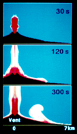
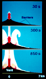
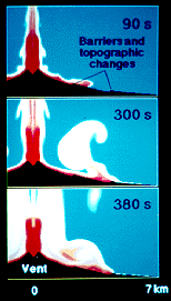
One of the central objectives of VESUVIUS 2000 is to produce physical models for forecasting future volcanic events and establishment of the effects of these events on the Vesuvius area infrastructure. Figure 1 illustrates current state-of-the-art computer modeling results of the distribution of pyroclastic flows (high density flows of volcanic debris) on the slopes of Vesuvius in the direction of Tyrrhenian Sea without and with engineering measures aimed at retarding or stopping the destructive powers of large- and medium-scale eruptions. Using volcanological and geophysical data of Vesuvius [23,27], these computer simulations were produced by first physically modeling magma ascent along the conduits to establish the conditions of gas and pyroclasts at the vents and subsequently using these conditions in a complex physical model of the eruption column [32,33]. The dense mixtures of volcanic material produced during large- and medium-scale explosive eruptions of Vesuvius cannot buoyantly rise as plinian columns but collapse at about 2-3 km above the vent after the jets lose their vertical momenta. Subsequently, the collapsed columns build pyroclastic flows which move along the slopes of the volcano at about 100 km/hr at 1000 C. At about 5 minutes after the column collapse of a large-scale eruption (Figure 1a) , the pyroclastic flow reaches the Tyrrhenian Sea at 7 km from the vent, and the flow of such an eruption cannot even be stopped by the 1000 m high Monte Somma relief on the North of the volcano [27]. The pyroclastic flow hazard at Vesuvius may be, however, significantly reduced by break-in-slopes and barriers located at appropriate places on the slopes of the volcano. These topographic changes and engineering measures change the radial motion of energetic pyroclastic flows and transfer their energy to vertical buoyant clouds (coignimbrite or phoenix plumes). (Figure 1b) shows that 30 m high barriers located at 2.5 and 4.5 km from the vent of Vesuvius are sufficient to stop at the second barrier an energetic pyroclastic flow from a medium- scale eruption and thus save many thousands of people who live near the sea. A much more dramatic effect of the topographic changes and barriers on the slopes of Vesuvius is illustrated on (Figure 1c) for a large-scale eruption. This eruption produces a pyroclastic flow which without engineering intervention measures reaches the Tyrrhenian Sea in about 5 minutes (Figure 1a) , but with the measures the flow is effectively stopped by the second barrier above the modern day highway at about 5 km from the vent. A combination of barriers and shelters on the lower slopes of the volcano can be effectively integrated into parks or urban-planned structures for the purpose of protecting more vulnerable population or give it more time to evacuate [12,28,34]. The results from computer simulations without barriers are consistent with the available data [35,36] of past eruptions of Vesuvius. Extensive computer simulations of large- and medium-scale eruptions with and without barriers, which are available in a videocassette entitled "Encounter with Vesuvius" [34], have also proved very useful for educators, school children, and population of the Vesuvius area who are very anxious to become informed about the risk and to actively participate in producing volcanic risk reduction guidelines [17,21,22,30].
The development of volcanic risk reduction guidelines for a densely populated area based on an interdisciplinary risk mitigation approach requires an effective integration of science and socio-economic and political conditions of the area. In the Vesuvius area this readily produces a conflict with those who have been managing the territory and permitted abusive urbanization and ignorance of the population about the risk. VESUVIUS 2000 is in effect a new policy for the territory and as such it is bound to be shunned by the area administrators and those who "manage" the risk.
7. Volcanologists and Politicians' Roles in Risk Mitigation
It would be too idealistic to expect an enthusiastic interdisciplinary cooperation of different parties in a large-scale endeavor to prevent a volcanic disaster, for these parties only collaborate if they have something to gain personally. I will not therefore even try to write on the professional and moral duty of volcanologists, politicians, and different actors on the territory to support the development of interdisciplinary volcanic risk mitigation guidelines for a densely populated area, but only point out several negative experiences associated with the VESUVIUS 2000 initiative.
In structuring the interdisciplinary initiative VESUVIUS 2000 for a support from the European Commission in 1995, many Italian and European volcanologists, geophysicists, civil protection, and other individuals and organizations were invited to participate, but many did not even respond, including the "family" of the Italian National Volcanic Group (Gruppo Nazionale per la Vulcanologia) and director of Osservatorio Vesuviano. This initiative was, however, supported by many institutions in Naples and by several Italian, French, and British Universities and research centers, and submitted for funding to the Environment Division DGXII of the European Commission. The Commission ultimately rejected the proposal based on highly subjective arguments produced by its "volcanological expertise" (Commissions' words). The proponents of the initiative protested to the Commission but so far no concrete actions have been taken to respond objectively to the charges of unprofessional proposal review procedures. In the mean time, the Commission is supporting with millions of ecus many other volcanological projects where no useful results have so far been produced to prevent future disasters in densely populated areas. The recipe for obtaining a support from the Commission depends on the "perceived" validity of the group which proposes the projects, and it is easy for an astute researcher to be associated with such a group and not be liable for producing the necessary results described in the work plan. On an Etna project which I coordinated for the Commission in 1992-1993 I found it impossible to terminate those who were not producing any results [37].
At present it is difficult to obtain any support for work on volcanoes in Italy unless this work is blessed by the "family" of the Italian National Volcanic Group and its representative within the Civil Protection who is not bothered by the conflict of interest. Too many years of unregulated management of the Italian volcanological resources has severely compromised the leadership of this group whole hold on power requires more compromise with those who are obstructing the work on Vesuvius and development of independent initiatives. This "leadership" has not only been "absorbed" within the system by becoming a client of those who obstruct progress in the Vesuvius area, but also acts as a patron to its own clients of researchers who have been unable to produce the necessary quantitative data for a serious progress in the Vesuvius area. As a consequence, many original volcanological ideas and initiatives have been lost, stolen, or abused, and many valid researchers have become inactive or changed their professions. The Emergency Plan for the Vesuvius area attests to the real capability of its proponents and their clients.
It is thus very unfortunate for the Vesuvius area population, and for the volcanological science in particular, that the Vesuvius area administrators do not appear to understand what it means to reduce the volcanic risk through the development of the territory, that the European Commission and its "volcanological expertise" have been unable to evaluate the scientific and practical merit of VESUVIUS 2000 and provide the necessary support to begin working seriously on the objectives which are impossible to realize with local and national resources, and that the proponents of the Emergency Plan for the Vesuvius area have been unable to support a project which allows for establishing a very high reliability of a selective, but not massive, evacuation plan.
7. Summary and Conclusions
Volcanic risk mitigation in a densely populated area is closely related to the potential hazard and to the socio-economic, cultural, and political conditions of the area. A hazardous environment diminishes the people's sense of security or increases their vulnerability either through their ignorance of the hazard or because of a poor socio-economic environment where they live. A well-organized environment is consistent with a high level of social and political organization of the population which decreases the vulnerability and therefore the risk. The risk equation thus constantly changes not only because of the changing hazard posed by the volcano, but also of the socio-economic, cultural, and political changes produced by the population on the territory. A well-educated population about the risk knows how to manage it, or how to prepare for the hazard and behave during an emergency. It is thus of fundamental importance to be able to confront the volcanic risk mitigation in densely populated areas from a global or integrated perspective where the conditions which led to this problem, or preventing its solution, may be key factors in developing effective volcanic risk mitigation guidelines.
Mitigation of volcanic risk through an emergency plan which tends to wait for an eruption and then try to manage it through evacuation is not a viable option for a densely populated area because of our limited ability to forecast future eruptions, deal with the evacuation of very large number of people, or protect an evacuated and rich territory for a long time. A more realistic approach of volcanic risk mitigation should involve the prevention of a disaster where the territory is reorganized for the purpose of confronting future eruptions with minimum panic and necessity to destroy the culture and leave the area to the speculators.
References
[1] Decker, R.W, and Decker, B.B., Volcanoes, W.H. Freeman and Company, New York, 1989.
[2] Decker, R.W, and Decker, B.B., Mountains of Fire, Cambridge University Press, New York, 1991.
[3] Skinner, B.J., and Porter, S.C., The Dynamic Earth, 2nd ed., John Wiley and Sons, New York, 1992.
[4] Wright, T.L., and Pierson, T.C., Living With Volcanoes, U.S. Geological Survey Circular 1073, US Government Printing Office, Washington D.C., 1992.
[5] Yanagi, T., Okada, H., and Ohta, K., Unzen Volcano: the 1990- 1992 Eruption, The Nishinippon and Kyushu University Press, , Kyushu, 1992.
[6] Self, S., and Rampino, M.R., The 1883 eruption of Krakatau, Nature 294, 699-704, 1981.
[7] Pinatubo Volcano Observatory Team, Lessons from a Major Eruption: Mt. Pinatubo, Philippines, Eos Transactions, American Geophysical Union 72, 545, 552-553, 555, December 3, 1991.
[8] Swanson, D.A., Casadevall, T.J., Dzurisin, D., Malone, S.D., Newhall, C.G., and Weaver, C.S., Predicting Eruptions of Mount St. Helens, June 1980 Through December 1982, Science 221, 1369-1376, 1983.
[9] Alfano, G.B., and Friedlaender, I., La Storia del Vesuvio Illustrata dai Documenti Coevi, Holm, Ulm a. D. Donau, Napoli, 1929.
[10] Arno, V., Principe, C., Rosi, M., Santacroce, R., Sbrana, A., and Sheridan, M.F., Eruptive history, In Somma-Vesuvius 114, ed. R. Santacroce, CNR Quaderni, Vol. 8, No. 114, Roma, 1987.
[11] Pesce, A., and Rolandi, G., Vesuvio 1944 L'ultima Eruzione, Giglio di Scafati, Napoli, 1994.
[12] Dobran, F., VESUVIUS 2000: Volcanic Risk Reduction in the Vesuvius Area Through Education and Simulations of Eruptive, Socio-Economic and Urban Systems Scenarios, International Congress on Civil Protection, 11-13 October, 1996, Napoli, Italy.
[13] Dobran, F., VESUVIUS: Waiting for a Catastrophe, Extreme Natural Disasters: Mitigation Strategies for the 21st Century, The Royal Society, London, 10-11 March, 1997.
[14] Pianificazione Nazionale D'Emergenza Dell'Area Vesuviana, Dipartimento della Protezione Civile, Italy, September, 1995.
[15] Volcan Popocatepetl: Estudios Realizados Durante la Crisis de 1994- 1995, Centro National de Prevencion de Desastres (CENAPRED), Mexico, 1996.
[16] Broad, W.J., El Popo's Rumblings Draw Volcanologists To Edge of Danger, The New York Times, May 14, 1996.
[17] GVES Newsletter 2/2, Global Volcanic and Environmental Systems Simulation, Napoli, October, 1996.
[18] Prevencion, Centro National de Prevencion de Desastres (CENAPRED), Mexico, 11, June, 1995.
[19] Plan Operativo del Volcan Popocatepetl, Centro National de Prevencion de Desastres (CENAPRED), Mexico, January, 1996.
[20] Volcano Eruption Darkens New Zealand Sky, The New York Times, June 18, 1996.
[21] GVES Newsletter 2/1, Global Volcanic and Environmental Systems Simulation, Napoli, December, 1995.
[22] VESUVIUS: The Making of a Catastrophe, Internet home page, http://tribeca.ios.com/~dobran, 1996.
[23] Dobran, F., Global Volcanic Simulation of Vesuvius, Giardini, Italy,1993.
[24] Civetta, L., Galati R., and Santacroce R., Magma Mixing and Convective Compositional Layering Within the Vesuvian Magma Chamber, Bull. Volcanol. 53, 287-300, 1991.
[25] Zollo, A., Gasparini, P., Virieux, J., Le Meur, H., De Natale, G., Biella, G., Boschi, E., Capuano, P., De Franco, R., Dell'Aversana, P., De Matteis, R., Guerra, I., Iannaccone, G., Mirabile, L., and Vilardo, G., Seismic Evidence for a Low- Velocity Zone in the Upper Crust Beneath Mount Vesuvius, Science 274, 592-494, 1996.
[26] Cioni, R., Civetta L., Marianelli, P., Metrich, N., Santacroce, R., and Sbrana, A., Compositional layering and syn-eruptive mixing of a periodically refilled shallow magma chamber: the AD 79 plinian eruption of Vesuvius, J. Petrology 36, 739-776, 1995.
[27] Dobran, F., Neri, A., and Todesco, M., Assessing the pyroclastic flow hazard at Vesuvius, Nature 367, 551-554, 1994.
[28] Dobran, F., Cronaca di un'eruzione annunciata, Sapere, 11- 16, November, 1994.
[29] Clark, M., Modern Italy 1871-1995, Longman, London, 1996.
[30] Dobran, F., and Luongo, G., VESUVIUS 2000: Project Summary and Field Work, Global Volcanic and Environmental Systems Simulation, Rome, Italy, 1995.
[31] Dobran, F., Vesuvius 2000: un progetto per la prevenzione della catastrofe, L'Osservatore Romano, January 25, 1996.
[32] Dobran, F., A. Neri, and G. Macedonio, Numerical simulation of collapsing volcanic columns, J. Geophys. Res. 98, 4231-4259, 1993.
[33] Dobran, F., COLUMN - A computer Program for the Analysis of Two- Dimensional and Transient Gas-Pyroclasts Mixtures in the Atmosphere, SYNTEC, New York, 1991.
[34] Dobran, F., Encounter with Vesuvius, 25 min. VHS video, 1995.
[35] Sigurdsson, H., Carey S., Cornell, W., and Pescatore, T., The Eruption of Vesuvius in 79 AD, Nat. Geogr. Res. J. 1, 332-387, 1985.
[36] Santacroce, R. (ed) Somma Vesuvius 114, CNR Quaderni, Rome, 1987.
[37] Dobran, F., Etna: Magma and Lava Flow Modeling and Volcanic System Definition Aimed at Hazard Assessment, Tipografia Massarosa Offset, Italy, 1995.
Figure 1. Distribution of pyroclasts at different times along the slopes of Vesuvius in the direction of Tyrrhenian Sea. (a) Column collapse of a large- scale eruption, similar to the A.D. 79 plinian eruption of Vesuvius, at about 3 km above the vent at 30 s, propagation of pyroclastic flow, partial column collapses feeding the flow and built-up of a phoenix column at the break-in-slope of the volcano at about 120 s, and the pyroclastic flow reaching the sea 7 km away from the vent at about 300 s illustrate the destructive power of such an eruption. (b) Effect of pyroclastic flow propagation with 30 m high barriers at 2.5 and 4.5 km from the vent following a medium-scale eruption similar to the sub-plinian eruption of Vesuvius in 1631. The pyroclastic flow of such an eruption reaches the sea in about 10 minutes, but with the barriers it is effectively stopped at 4.5 km from the vent. (c) Effect of pyroclastic flow propagation with 30 m high barriers and topographic changes at 2.5 and 4.5 km from the vent following the collapse of a large-scale plinian eruption of Vesuvius similar to A.D. 79. A combination of such engineering measures integrated within the landscape or parks on the slopes of the volcano may be used effectively to avoid a large-scale evacuation of the population or give it more time to escape. The red color denotes very high, and blue color very low, concentrations of pyroclasts.