CONTENTS
Accurate forecasting of future volcanic eruptions in the Vesuvius area calls for detailed understanding of the past behavior of the volcano and extrapolation of this behavior into the future. To accomplish this goal requires the development of a Global Volcanic Simulator (the Simulator). This Simulator is a computer model of the volcano which incorporates physical and mathematical models and geological and geophysical data or information about the volcano's substructure. These data are required to ascertain the origin and composition of volcanic deposits, magma and lava flows, presence of aquifers or underground reservoirs of water, strength, elasticity and plasticity of magmas, lavas, surrounding rocks and soils, etc. Such data and mathematical and physical techniques are then used to develop constitutive equations or models of the material behavior at the microscale and macroscale levels for the magma, lava, soil, and pyroclasts dispersions involving several phases, inhomogeneities, and anisotropic behavior. These material models are subsequently used in basic physical laws of mass, momentum, and energy conservation to produce an overall mathematical model suitable for solution on efficient computers that may require taking advantage of their special design or architecture. Such a computer model of the volcano or Simulator can then be used to produce most probable eruption scenarios or hazard maps, as well as the uncertainties of these scenarios due to the lack of the precise information about the volcanic system. The development of an effective Simulator for Vesuvius does not only depend on future scientific breakthroughs in several fields of science, but also in bringing together responsible agencies and researchers with different cultural backgrounds.
A Simulator requires reliable data to initiate computer simulations and for constraining and verifying the simulations. It is important to note that if these data are incomplete or unreliable the forecasts are also unreliable, no matter how precise is the physico-mathematical model of the volcano. Initial data for simulations determine the starting condition or initial state of the volcano. These include thermofluid-dynamic properties of magma, gas, and pyroclasts, and structural mechanics properties of the volcanic edifice. When supplemented by similar data or boundary conditions which specify an interaction of the volcano with its surroundings, these data are used to assess the behavior of the volcano in the future. If a simulation is initiated from a closed-conduit state, the simulation should be able to predict subsequent volcanic eruptions or future times associated with conduit opening, dispersions of volcanic products above the volcano and their interaction with infrastructures on the slopes of Vesuvius. Since the volcanic system is very complicated and its internal states very difficult to define during an eruption, it is preferable to initiate the simulation when the volcanic conduit is closed in order to minimize the uncertainties of the starting conditions. A volcano which is externally inactive may remain in this state for a very long time and tends to "forget" its initial conditions with time, thus minimizing the uncertainties in the specification of initial data. This is not, however, true for the constraining data or boundary conditions which strongly control the future evolution of the volcanic system.
Proper initial data for initiating simulations should be, therefore, obtained when the conduit closed after the 79 Pompeii eruption in order to avoid a large uncertainty in specifying the volcanic system during an open-conduit condition. The closure of the conduit after 79 apparently occurred around 205 and requires further studies. The subplinian eruption of Vesuvius in 1631 is a well-known eruption of this volcano and provides a good test case for fine-tuning of the Simulator's predictive capabilities. This eruption produced a plinian column, caldera collapse, pyroclastic flows and surges, and lahars. In order for the Simulator to predict this eruption it needs to simulate magma supply, differentiation, and crystallization in magma chamber which lead to conduit opening and subsequent closure after the driving pressure for magma discharge from the chamber is reduced and the eruption terminated. The eruption of 1631 did not, however, completely close the conduit of Vesuvius at least until 1944, during which time the volcano was producing strombolian and effusive eruptions. To forecast these small-scale eruptions requires very high quality data and very sophisticated physical models that are not expected to become available in the foreseeable future.
For the past 35,000 years, Somma-Vesuvius has exhibited various types of activities. Large-scale plinian eruptions each erupted several cubic kilometers of material and occurred every few thousand years, whereas the intermediate-scale subplinian eruptions occurred every few centuries and erupted about ten times less material. The smaller-scale strombolian and effusive events occurred every few years or decades and it appears that these eruptions normally follow the plinian and subplinian eruptions until the conduits of Vesuvius close. A common feature of plinian eruptions is that they were intermittently interrupted by partial column collapses which produced pyroclastic surges and flows and terminated with the interaction of magma with water from underground aquifers. Recent plinian and subplinian eruptions are characterized by the emission of highly differentiated trachytic and phonolitic magmas. Their deposits contain limestones, various thermometamorphosed marble and skarn lithic ejecta that suggest the location of magma chamber and/or magma fragmentation levels within the Mesozoic carbonate basement (the Mesozoic era lasted between 225 and 65 million years ago) between 3 and 5 kilometers below the surface of the volcano. Recent geophysical experiments at Vesuvius using seismic tomography did not, however, produce any new information regarding the existence of a reservoir at these depths. The subplinian deposits do not contain carbonate lithic ejecta, suggesting that the magma reservoirs and/or magma fragmentation levels were located above the Mesozoic carbonate basement. While the petrological and volcanological evidence suggest that the volcanic activity at Vesuvius can be associated with a periodic magma supply into the system, it also needs to be stressed that these data have not been substantiated by either geophysics or thermofluid constraints.
The development of the Simulator also requires establishing physical and chemical characteristics of magma supply, magma differentiation and assimilation, volcanic edifice, mineralogy, and geothermal gradients; thermofluid-dynamic constraints of magma transport; geochemical and isotopic characteristics of magma; etc. Detailed studies of stratigraphic layers and their spatial and temporal correlations during the eruption of 1631 are required to establish composition and granulometry of the erupted material and association of these data with the conditions at the vent during the course of the eruption, provenance and characterization of lithics, identification of the location and thermal states of aquifers, and reconstruction of the time-wise behavior of mass flow-rates during the plinian and pyroclastic flow phases of the eruption. Effective geophysical studies at Vesuvius should involve high-resolution three-dimensional seismic tomography aimed at identifying significant volcanic structures below the Grand Cone and Somma caldera, since recent studies have been unable to find any of these structures including a magma reservoir.
Vesuvius can lie dormant for long periods of time. Consequently, the quantification of time scales over which magma storage and differentiation take place is of vital importance. Current understanding of the subsurface of volcanoes is poor and only few constraints are available on the time required for magma storage and differentiation between eruptions. A serious geochemical research is thus needed to produce new data aimed at better interpretation and modeling of magmatic processes associated with the past activity of Vesuvius, and of the 1631 eruption in particular. Although a great deal of information on the deposits of recent plinian and subplinian eruptions of Vesuvius is already available in the scientific literature, much more work is required to quantify this information for use in physical models of eruption processes. For this purpose, data are required on the spatial and temporal evolution of deposits, sedimentological structures, granulometry, clast types and morphology, and field and laboratory studies of magma-water interaction. A significant effort should also be directed at identifying the fall-out, pyroclastic flow, lithics provenance and distribution, and hydromagmatic components in the eruptive sequences and their spatial and temporal relationships. An accurate identification of the volcanological character of each depositional layer of the 1631 eruption of Vesuvius is essential for verifying magma chamber, magma ascent, and pyroclastic dispersion models to be used for reliable assessment of future volcanic events in the Vesuvius area.
Magma-water interaction processes at Vesuvius are poorly understood but are very important and should be properly modeled by any realistic magma ascent model. This requires knowledge of the size, capacity, and physical characteristics of aquifers, as well as the physical characteristics of soil and rocks between aquifers and volcanic conduit(s). Hydrogeological studies at Vesuvius should be, therefore, directed at the reconstruction of a hydrodynamic model for the Vesuvius area, since past hydrogeological surveys provide only for the reconstruction of a regional flow and approximate evaluation of groundwater resources. The possibility of avalanches and landslides from the Grand Cone is very real and can be assessed through geotechnical studies which aim to produce geological, geomorphological, lithotechnical, slope, landslide, and soundings maps.
Structural investigations of Somma-Vesuvius should be directed at establishing relationships between the activity of the Somma volcano (regional tectonism, origin of the caldera) and the structure of the Grand Cone in order to ascertain weakness areas along which sector collapses are possible. For this purpose, use can be made of Landsat and aerial photo analyses to study the geomorphology, field survey of fault fractures and dykes to analyze structures, analyses of drill-hole and geophysical data to ascertain deep structures, and evaluation of the volume of the caldera and comparison with plinian eruption volumes. The results of this study should permit an assessment of the influence of regional tectonism on the volcanic activity, evaluation of lateral sector collapses of Somma-Vesuvius, and definition of a rheological model for the volcano. An analysis should also define the depth and shape of magma chamber(s) related to Somma's collapses and hazard associated with Grand Cone flank collapses. This study needs to be further complemented by physical modeling of the stability of volcanic cone. Rock slides and rock avalanches may produce a large hazard at Vesuvius. This can be triggered by earthquakes or an internal pressure increase due to magma intrusion, magma-water interaction, or heavy rains. During the eruption of Mt. St. Helens in 1980 a large part of the mountain blew up as a result of a landslide produced by an earthquake. A similar event occurring in the Vesuvius area would produce a catastrophe. Such a scenario is very serious and it possibly occurred in the past, because the sea-ward part of the Somma caldera rim is missing.
The volcanic system of Vesuvius may be conveniently divided into different parts or domains characterized by unique properties or characteristic physical phenomena. These parts may consist of magma chamber or reservoir, conduit, soil or country rock, and pyroclasts domains. The magma reservoir domain consists of an open system for mass, momentum, and energy transfer involving crystallization, exsolution, melting, and solidification. The conduit domain can be characterized by propagating fractures in which magma exsolves dissolved gases, fragments into pyroclasts, and interacts with conduit walls and surrounding aquifers. The soil or rock domain encloses magma chamber and conduit domains and can be characterized by the elastic, plastic, and nonhomogeneous material behavior. The pyroclasts domain involves a region where the volcanic products mix with the atmosphere and interact with the infrastructures on the slopes of Vesuvius. The extents of these domains depend on modeling complexity and requirements of simulations (more or less detail or accuracy).
Modeling of elastic, plastic, and nonhomogeneous media, and multicomponent and multiphase flow phenomena in magma reservoir, conduit(s), and atmosphere requires the development and validation of appropriate physical models and associated constitutive equations. Magma reservoir modeling should account for several crystallizing phases, crystallization kinetics, and gas exsolution, whereas the conduit modeling should account for crack propagation due to intruding magma, magma- water interaction, magma fragmentation, and erosion of conduit walls. Rock or soil modeling should be based on the deformation maps which characterize the elastic, plastic, or viscoelastic characteristics of rocks at different pressures and temperatures. Furthermore, the closing phase of an eruption requires modeling of the conduit and magma reservoir wall collapses and can be accomplished by using a multiphase modeling approach and deformation maps. The pyroclasts domain modeling should involve particles or tephra of several sizes, mixing of magmatic gases with the atmosphere and interaction with pyroclasts, particle-particle interactions and two-way turbulence coupling between gas and particles, condensation of water vapor, and interaction of volcanic products with the infrastructures on the slopes of the volcano. Some of this modeling capability already exists.
The effectiveness of global simulations depends on an effective combination of different domains of the volcanic system into an overall computer model suitable for a multiprocessor computer environment where to each processor of a multiprocessor computer, or to each computer in a distributed computer environment, is assigned a single domain or part of this domain. Interactions between domains can be accounted by scheduler-supervisor processors which update inter-domain boundary data and assign computational times to free processors. The appropriate division of computational tasks among processors in a parallel computational environment requires careful optimization studies involving physical models, numerical algorithms used to transform the mathematical form of physical models into algebraic equations for solution on computer, and computer architectures.
The ultimate utility of a Global Volcanic Simulator of Vesuvius is to produce hazard maps, educate the population of the impending danger of the volcano, and urban planning of the area. Hazard maps can be produced by performing simulations from the initial data after the conduit closed following the eruption of 79 with different parameters of the volcanic system which represent the mean values and variances of volcanological, petrological, and geophysical data pertaining to the volcanic complex. It is important to realize that the uncertainties of these data will also produce uncertainties in eruption forecasting, or that the volcanic hazard maps produced in this manner can only produce probabilities associated with different volcanic events (lava flow, pyroclastic flow, ash fall, lahars, etc.) at different times in different regions in the Vesuvius area. Perhaps the best use of the Simulator is to educate the adult population, school children, policy makers, city planners, and insurance companies, for constructing the appropriate barriers or shelters on the slopes of the volcano to protect some areas of the territory, enforce building codes to withstand the fury of certain volcanic eruptions, construct effective evacuation routes, or replan the territory to resettle some population away from the most dangerous areas.
Global Volcanic Simulator is a very useful tool to mitigate the volcanic risk in the Vesuvius area. It consists of physico-mathematical models of the volcanic system which model different parts of the volcano. Current capabilities of the simulator allow for magma chamber, volcanic conduit, and pyroclasts distribution modeling. The magma chamber model accounts for reservoir volume, temperature, and pressure changes, variable rates of magma inflow and outflow from the chamber, and varying elastic, plastic, and heat transfer characteristics of magma reservoir surroundings. Different types of magma ascent models allow for steady-state, time- varying (transient), isothermal, and non-isothermal simulations, and account for magma flow regime changes and melting of conduit walls caused by decreasing pressure and heat loss from the ascending hot magma. A combination of these models can be used to forecast long-term eruptions, durations of eruptions, as well as the likely values of conduit size and gas-pyroclasts pressure, temperature, and velocity distributions at the conduit exit. These conditions can then be used in a volcanic column or plume model of the Simulator to produce temporal and spatial distributions of volcanic products in the atmosphere and along the slopes of the volcano. This latter model accounts for pressure and temperature changes of gas (water vapor) and pyroclasts as they interact with the colder atmosphere.
The current Simulator forecasts that subplinian eruptions of Vesuvius occur every few hundred years, each of which has a duration of about 20 hours. A plinian eruption which discharges about 10^8 kg/s of material can occur, however, only every few thousand years. The duration of such an eruption is also about 20 hours. Although these results are consistent with volcanological deposits (eruption volumes, magma compositions) and chronicles (durations of eruptions) it should be noted that they also depend on the sub-surface characteristics of the volcano which are not adequately known at present.
By carrying out many simulations with different parameters to account for their uncertainties, it can be concluded that a future subplinian or plinian eruption of Vesuvius should occur with equal chance within the next 100 years, with an uncertainty of plus or minus 100 years. Simulation results show that since the last plinian eruption in 79 Vesuvius produced four subplinian eruptions (in 370, 813, 1251, 1744), which may be compared with medieval sources on the basis of which significant eruptions occurred in 472, 685, 787, 1036, 1139, and 1631. On the basis of this comparison which demonstrates that the "predictions" of past subplinian eruptions are reasonable, we can expect in the twenty-first century another subplinian or plinian eruption of Vesuvius. By this time the magma chamber pressure will increase sufficiently to produce another catastrophic failure of the chamber and possibly a plinian eruption.
Computer simulations of pyroclasts dispersal in the atmosphere and along the slopes of Vesuvius of medium-scale (subplinian) and large-scale (plinian) eruptions also suggest dramatic consequences, unless the territory is prepared to confront these eruptions. These simulations were produced from the conditions of gas and pyroclasts at the conduit exit obtained from a steady-state and isothermal magma ascent model. This model is based on a fluid dynamic physical model that accounts for gas exsolution, bubble growth, fragmentation, and flow regime changes of magma in the conduit. The volcanic column model accounts for the complex effects associated with the mixing of volcanic products in the atmosphere and propagation of these products along the slopes of the volcano. The input data for these magma ascent and volcanic column models are shown in the table below for three different mass eruption rates, representing three different scales of eruptions. The large mass eruption rate is consistent with the gray or last eruption phase of Vesuvius in 79 when the pyroclastic flows swept over a large part of the territory to the east, along the coast, and to the west, whereas the medium mass eruption rate is typical of a subplinian eruption such as that of 1631 when the pyroclastic flows also destroyed many surrounding towns. The small mass eruption rate corresponds to an eruption that is an order of magnitude smaller than the large-scale eruption and may represent the final phases of 1906 and 1944 eruptions. The eruption conditions at conduit exits shown in the table correspond to the magma composition pertaining to the eruption of 79, whereas the locations of magma chambers correspond to the available geological and geophysical data of Vesuvius. The conduit lengths and associated magma chamber pressures in the table reflect, therefore, different locations of plinian and subplinian magma chambers, whereas the conduit diameters were determined by the physical model of magma ascent as discussed above. The pyroclasts size of 100 mm employed in simulations represents one of the more mobile parts of the flow, since larger pyroclasts tend to be deposited at shorter distances from the vent whereas the smaller ones tend to follow the ascending hot plumes forming above the collapsed portion of the column or fountain and above the pyroclastic flow.
| Scale of the eruption | Large | Medium | Small |
|---|---|---|---|
| Mass eruption rate (kg/s) | 1.5x10^8 | 5.0x10^7 | 1.5x10^7 |
| Conduit length (km) | 5 | 3 | 3 |
| Magma chamber pressure (MPa) | 124.7 | 74.7 | 74.7 |
| Magma chamber temperature (K) | 1,123 | 1,123 | 1,123 |
| Pyroclasts size (micrometers) | 100 | 100 | 100 |
| Dissolved water content of magma (wt%) | 2 | 2 | 2 |
| Conduit diameter (m) | 100 | 60 | 40 |
| Gas velocity at the vent (m/s) | 118 | 130 | 135 |
| Pyroclasts velocity at the vent (m/s) | 110 | 115 | 116 |
| Temperature at the vent (K) | 1,123 | 1,123 | 1,123 |
| Pressure at the vent (MPa) | 1.3 | 0.96 | 0.65 |
| Particle volumetric fraction at the vent | 0.067 | 0.052 | 0.0365 |
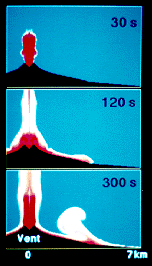
The results from computer simulations of the eruptions described in the table produce collapses of volcanic columns and pyroclastic flows which move along the slopes of Vesuvius as illustrated in (Figure a) for the large eruption. At about 20 seconds after the beginning of this eruption, the volcanic column reaches a height of about 3 kilometers above the vent or conduit exit. This column then collapses and spreads radially a high density current of very hot material or mixture of gas and pyroclasts from broken magma. At 60 seconds, the ground-hugging pyroclastic flow reaches a distance of about 2 kilometers from the vent, at 120 seconds it reaches 4 kilometers, and at 5 minutes the flow enters the Tyrrhenian Sea at 7 kilometers from the crater. The 1000-meter-high barrier of Monte Somma cannot even stop the flow from the medium-scale eruption on the northern slope of the volcano, because this barrier is too close to the crater of Vesuvius where the flow is very energetic. In 5 minutes a large-scale eruption of Vesuvius is thus capable of destroying completely all of the surrounding towns, if this eruption is not strongly deflected in only one direction by the prevailing winds. But even medium- and small-scale eruptions could be devastating, for it takes the pyroclastic flow of the former only 10 minutes to reach a given distance as compared to a large-scale eruption. The flow from a small-scale eruption also reaches the Tyrrhenian Sea in about 16 minutes but is arrested by Monte Somma, both in the directions of Somma Vesuviana and Ottaviano (see references).
The results from these simulations are consistent with eruption deposits around the volcano and from 79 and 1631 chronicles. In 79 the pyroclastic flows reached the sea in few minutes, whereas the pyroclastic flows of the Avellino eruption (ca. 1500 B.C.) swept over the Monte Somma on the north. The flows and surges during the subplinian eruption of 1631 also reached the Tyrrhenian Sea and destroyed many local towns. It should be noted, however, that these computer simulations do not account for the effects of asymmetry that can be caused by wind; thus they underestimate the real ones, because the asymmetry causes the ejected material to be distributed on a smaller area.
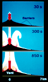
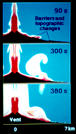
The pyroclastic flow hazard at Vesuvius may be, however, significantly reduced by break-in-slopes (leveling of the terrain) and barriers located at appropriate places on the slopes of the volcano. These engineering measures can change the direction of movement of pyroclastic flows by forcing them to move vertically and form phoenix clouds. (Volcanologists call these clouds co-ignimbritic because they form from ignimbrites or volcanic deposits. I and my collaborators named them, however, "phoenix clouds" because they rise from ashes of the older cloud. In Egyptian mythology the bird phoenix lives for several hundred years. It then consumes itself by fire and rises from its ashes young and beautiful to live through another cycle.) These columns transport hot gas and ash into the atmosphere where they cool in the colder atmosphere. The cool ash subsequently falls to the ground as tephra where it posses much less hazard to the population. (Figure b) shows that 30-meter-high barriers located at 2.5 and 4.5 kilometers from the crater of Vesuvius are sufficient to stop, at the second barrier, an energetic pyroclastic flow from a medium-scale eruption. A much more dramatic effect of the topographic changes and barriers on the slopes of the volcano is illustrated in (Figure c) for a large-scale eruption. This produces a pyroclastic flow which without barriers reaches the sea in about 5 minutes, but with barriers and break-in slope the flow is effectively stopped by the second barrier above the highway A3 at about 5 kilometers from the crater.
The location of the second barrier at 4.5 kilometers from the crater corresponds to the location of the State Highway A3 which runs parallel to the coast. This location was chosen because if one were to implement such a construction it should be much easier to do so on a public land rather than on a private one. The "barriers" in computer simulations were employed only to assess the scientific feasibility of mitigating subplinian and plinian eruptions and do not in any way suggest that they could be or should be constructed, for this requires an engineering feasibility study which has not yet been conducted. Such a study should not only investigate the best barrier size and location, but also the suitability of existing obstructions on the territory that may already serve as barriers. These obstructions are widely scattered throughout the area in the form of apartment complexes, many of which are 9 stories or about 25 meters high. Many more buildings in Portici, Ercolano, Torre del Greco, Torre Annunziata, and Castellammare di Stabia are 15-20 meters high and were not only constructed without antiseismic building codes, but also fail as candidates for barriers because they could be easily destroyed by the high velocity pyroclastic surges and flows or other types of volcanic events (earthquakes). Such flows would also be channeled along the streets bounded by these buildings, which would probably create other unforeseen consequences for the population.
Any future planning of barriers, shelters, etc. in the Vesuvius area requires at first an assessment of the most probable eruption scenarios and studying the effects of these scenarios on the existing infrastructures to determine possible socio-economic and cultural losses. The presence of the volcano changes many construction methods and building practices that have not yet been properly addressed. Collapses of buildings onto the narrow streets and bridges on Highway A3, burning of gas stations out of control, families trying to reach their loved ones, stuck automobiles blocking escape routes, misaligned railways tracks causing Circumvesuviana and National Railway lines to terminate services, deliberate actions by camoristi bands to "control traffic" or exodus of the population from the Vesuvius area, will produce unforeseen human behaviors and consequences during future emergences unless the population and the territory are prepared for the calamities.
A combination of engineering intervention measures aimed at stopping or diverting pyroclastic, mud and lava flows can be effectively integrated into parks or urban-planned structures for protecting more vulnerable population or give it more time to escape in the event of an emergency. Such engineering protection measures cannot attempt to duplicate the Great Wall of China surrounding Vesuvius, for this would only create an illusion of safety and undesirable environmental impacts. Instead, these structures would have to be intelligent and should be built only after extensive studies of their environmental and protective impacts on the territory. For this purpose, parks, recreational areas, and industrial parks (soft industry, for example) constructed at strategic locations could not only serve their intended purposes of creating better quality of life, but also provide some built-in passive and active protection measures that would become operational before and during an emergency or eruption.
Probabilistic decision making rules involve quantifying the uncertainties present in the situation in terms of probabilities that are used to establish the consequences of events and decisions for the purpose of assessing the corresponding losses or gains from decisions. Our conclusion above that the future subplinian or plinian eruption of Vesuvius will occur within the next 100 years, with an uncertainty of plus or minus 100 years, also needs to be justified from the probabilistic point of view based on the past eruption history of the volcano.
The eruptive history of Vesuvius for the past 300,000 years provides this information. This history demonstrates that the periods between the eruptions and magnitudes of eruptions are stochastic in nature and follow well-known probabilistic laws which are more reliable for larger than for smaller eruptions. The results from this information, extrapolated into the future, demonstrate that the probabilities of large explosive eruptions are:
Probability(500 years)=0.99
Probability(100 years)=0.90
Probability (50 years)=0.75
Probability(10 years)=0.30
Probability(1 year)=0.04
These results attest that it is almost certain that a large eruption of Vesuvius will occur every 500 years. Since the last large eruption in 1631 (367 years ago) a very high probability thus exists for a similar or larger eruption in the near future, and especially in the 21st century as also assessed independently by the Global Volcanic Simulator as discussed above. When this probabilistic information is combined with the decision theory involving small, medium, and large eruptions it can be shown that the likelihood ratios of future eruptions are as follows:
Likelihood ratio(1 week for evacuation) is greater than 1000
Likelihood ratio(1 month for alert) is greater that 100
Likelihood ratio (100 years) for prevention is greater than 0.1
It should be clear, therefore, that in the absence of clear eruption precursors it is not possible to predict the eruption on short notice or several weeks in advance as stated by the volcanologists who proposed the Vesuvius evacuation plan and that the only way to protect the population is through a long term prevention strategy. For the eruptions of Mt. St. Helens in 1980 and Pinatubo in 1991 clear precursors manifested themselves only several days before the eruptions and our weather predicting capacity does not exceed likelihood ratios of about 5. The architects of the Vesuvius evacuation plan (Osservatorio Vesuviano, Protezione Civile, Gruppo Nazionale per la Vulcanologia) fail, however, to notice these laws of nature and will continue to ignore and deny them because to survive they must constantly project an image that they can really protect the population by only monitoring the volcano. This kind of policy is scientifically unjustifiable and only demonstrates that those who support it are blind to the alternatives or are only interested in their own personal interests.
Dobran, F. Volcanic Processes: Mechanisms in Material Transport. Kluwer Academic/Plenum Publishing, New York, 2001.
Somma-Vesuvius, ed. R. Santacroce, CNR Quaderni 114, Roma, 53-103, 1987.
Bacon, C.R., and Druitt, T.H., Compositional Evolution of the Zoned Calcalkaline Magma Chamber of Mount Mazama, Crater Lake, Oregon, J. Geophys. Res. 98, 224-256, 1988.
Dobran, F., Theory of Structured Multiphase Mixtures, Springer Verlag, 250pp., New York, 1991.
Dobran, F., Modeling of structured multiphase mixtures, Int. J. Eng. Sci. 30, 1497-1505, 1992.
114 Ui, T., and Fujiwara, H., Debris Avalanche Database: a Tool for the Assessment of Volcanism, 29th Int. Geol. Congress Abs. Vol. 1, Kyoto, 504, 1992.
Civetta, L., and Santacroce, R., Steady-State Magma Supply in the Last 3400 Years of Vesuvian Activity, Acta Vulcanologica 2, 147-159, 1992.
Dobran, F. Nonequilibrium Flow in Volcanic Conduits and Application to the Eruptions of Mt. St. Helens on May 18, 1980, and Vesuvius in AD 79, J. Volcanol. Geotherm. Res., 49, 285-311, 1992.
Bellucci, F., Corniello, A., and De Riso, R., Geology and Hydrogeology of Somma-Vesuvio Volcano (Southern Italy), Proc. XXIV Int. Cong. AIH, 137- 149, Oslo, 1993.
Dobran F., Global Volcanic Simulation of Vesuvius, Giardini, Pisa, 1993.
Dobran, F., Neri, A., and Macedonio, G., Numerical Simulation of Collapsing Volcanic Columns, J. Geophys. Res. 98, 4231-4259, 1993.
Papale, P., and Dobran, F., Modeling of the Ascent of Magma During the Plinian Eruption of Vesuvius in AD 79, J. Volcanol. Geotherm. Res. 58, 101- 132, 1993.
Special issue of J. Volcanol. Geotherm. Res. 58, 1993.
Dobran F., Incontro con il Vesuvio, Sapere, November, 11-16, 1994.
Dobran, F., Prospects for the Global Volcanic Simulation of Vesuvius, Accademia Nazionale dei Lincei 112, 197-209, Rome, 1994.
Dobran, F., Neri, A., and Todesco, M., Assessing the pyroclastic flow hazard at Vesuvius, Nature 367, February 10, 1994.
Dobran, F., Etna: Magma and Lava Flow Modeling and Volcanic System Definition Aimed at Hazard Assessment, Topografia Massaroa Offset, 277pp, 1995.
Zollo, A., Gasparini, P., Virieux, J., Le Meur, H., De Natale, G., Biella, G., Boschi, E., Capuano, P., De Franco, R., Dell'Aversana, P., De Matteis, R., Guerra, I., Iannaccone, G., Mirabile, L., and Vilardo, G., Seismic Evidence for a Low- Velocity Zone in the Upper Crust Beneath Mount Vesuvius, Science, 274, 592-494, 1996.
Special issue of J. Volcanol. Geotherm. Res. 82, 1998.
Dobran, F., Magma Chamber Dynamics and Energetics and Vesuvius Eruption Forecasting, submitted for publication, 1999.